|
A
General Overview of the Fortifications in the locality of Mellieha
|
||
|
|
More often than not
throughout there long history, the main threat to the Maltese islands has
come from across the sea. The
appearance of sails on the horizon frequently meant pillage, death and
slavery. The sole refuge afforded to the inhabitants were the few
fortified towns and an ever-constant vigilance. The need for a reliable system to warn of approaching danger
meant that many places along the coastline, particularly the
secluded and vulnerable landing sites along the northern shores of the
island, had to be watched continually. Amongst such places were the bays
and inlets of Mellieha and the Fliegu. The importance of
these areas to the safety of the island was appreciated early in the
history of the island. Gian Frangisc Abela, writing in 1647, could already
write of a militia post known as il-Borgio tal-Melleha, a
place-name which evidently betrays the site of an ancient military
structure. In Abela's time,
Melleha was then one of 31 'gaurdie
marine ... intorno l-isola'
and one of only five around the island which were important enough to be
guarded also by day by the men 'deputati
a questa guardia da i Giurati della Città Notabile'.
This pre-occuptaion can be traced even earlier into the middle
ages. The mandati records for
1482, for example, show the payments which were made to Frankinu Xelluki
for his services 'comu guardianu dila Mallacha'.
Prof. Stanley Fiorini has shown that on more serious occasions, as
happened in 1520 when the Turks landed in force at Melleha,
a military camp (campu) was established along the heights by the Maltese militia in
order to keep watch on the Turkish movements
and possibly also serve as a base for the exchange of hostilities. For most of its
history, however, the defence of the Mellieha area fell under the
responsibility of the parish of Naxxar.
The militia list of 1419-20 shows that
Naxxar and its associate villages contributed 262 men to the
island’s militia force, 20 of whom owned a horse. Under the Order
this responsibility remained the prerogative of the Captain of
the Naxxar militia, and the village itself became the main staging
post for the
Birkirkara-Naxxar-Qormi regiment of country militia charged with the
defence of the northern parts of the island. It was not until
well into the seventeenth century that Mellieha and the Fliegu received
any form of permanent defences. The first fortified structure built to
provide some measure of security in the area was the Red Tower, erected
during the reign of Grand Master Lascaris Castellar.
This sturdy, massive structure, built on
the same plan as the set of towers erected earlier in the century
by Grand Master Wignacourt at St.
Paul’s Bay, Marsaxlokk, Marsascala, Delle Grazie, Marsalforn, and
Comino, was designed more as a fort rather than a simple watch-post. The characteristic
feature of the Red Tower (Torre Rossa) were the corner turrets, a
rudimentary form of bastions designed to allow some degree of close-in
defence by enabling enfilading fire along the faces of the structure.
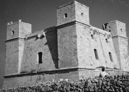
The Red Tower or Fort St. Agatha
(sometimes also referred to Torre Caura) was followed, nearly a decade
later, by two other works of fortification erected in the vicinity at
Ghajn Hadid and l-Ahrax. Actually,
these formed part of a string of thirteen signalling towers built by Grand
Master de Redin in 1658-9 and designed to form a chain of communication
whereby alarms were relayed visually from one post to the next all the way
down to Valletta. With the introduction of these towers the knights also
re-organized the system of coastal watch, replacing the old system of
local militia guards with fixed garrisons paid for by the Universitas.
Each tower was manned by a bombardier and three assistants
with annual salaries of 30 and 24 scudi respectively. The Ghajn Hadid
tower, north of Selmun, was actually the first to be built. Before it was
demolished by an earthquake in 1855, it stood some 36 ft high and had two
vaulted rooms internally, one on each floor with the main.
The sole entrance was securely located on the first floor and
reached by a wooden retractable ladder, sometimes also made of rope. The
base of the tower right up to the level of the lower cordon was given a
pronounced batter but above this the walls rose vertical to terminate in a
low parapet fitted with shallow embrasures clearly designed to
permit the firing of light cannon. A spiral staircase set into the
thickness of the wall just to the left of the main entrance led to the
roof. The plan and
configuration was the same for the L-Ahrax tower, as for the rest of the
De Redin towers. All mounted
small artillery pieces, generally one or two 3-pdr iron cannon kept mostly
for signalling purposes and in 1659 these were each issued with two moschettoni
di posta, or large heavy muskets. Next to the Ghajn
Hadid tower stood a small defensible room once used to accommodate the
militia sentinels. It is not yet clear whether this building actually
pre-dates the tower, or if it was added later. A similarly interesting
feature are the small rubble-wall pans built around the tower and
apparently used to house farm animals. The whole ensemble tends to betray
a self- supporting out-post that must have been difficulty to reach and
re-supply No other defensive works were erected in the area throughout the remainder of the seventeenth century. The picture changed dramatically, however, during the second decade of the following century. In 1714, under the influence of its French military engineers, the Order embarked upon the construction of an ambitious coastal defence programme. This practically involved the fortification of every bay and inlet around the island with gun-batteries, redoubts and entrenchments. The reasoning behind this strategy of coastal defence hinged around the notion that the fortification of the bays would prevent the enemy from attempting to disembark troops, and in trying to do so, the losses would be so high that the invading forces would be unable to carry on with an assault on the main fortresses around the harbour. Between 1715 and mid-1716 a total of some 41,561 scudi was spent on the construction of batteries around the coast of Malta and Gozo. Mellieha itself was fitted out with two batteries and a redoubt, while the coastline along the Comino Channel was given four redoubts and three batteries. The main elements in this defensive strategy were the gun-batteries. These were designed to mount heavy cannon and engage the enemy warships seeking to disembark the troops. Basically, these consisted of solid open platforms ringed by parapets fitted with embrasures and protected to the rear by blockhouses and redans with loopholed walls. There was no standard plan to their design although most were given semicircular gun-platforms. The ones to be seen at Mellieha, Marfa and Armier provide the best surviving examples still to be found in Malta. The most impressive of these is undoubtedly the Vendôme Battery at Armier, one of the largest of its type ever built. Its large semicircular platform is ringed by nine embrasures and a ditch while the gorge is occupied by a blockhouse and redan. In 1785 it was armed with five 8-pdr and four 12-pdr iron guns. Later on in the century it was fitted with platforms for mortars. The Wied Mousa Battery, also situated along the Fliegu coastline, although having lost part of its blockhouse and redan as a result of later interventions, has a very well-preserved battery fitted with thick parapet and 'zonqor'-slabbed gun-platform. Perhaps the most fascinating, however, was Westreme Battery, located on the right hand side of Mellieha Bay. Although this has lost its gun-platform and parapet, it retains a unique barrel-vaulted blockhouse, currently under restoration, which is amply fitted with musketry loopholes. This structure was placed diagonally along the gorge of the battery in such a manner that two of its outer faces served as a redan and helped defend the landward approaches to the work. Where opportune, such as at L-Ahrax, only a gun-platform was constructed since the existing tower was incorporated into the design and used to provide the necessary storage and accommodation facilities. A fourth battery, was situated on the left side of the Mellieha bay, on the site currently occupied by the large hotel. Known as Tonnara, Fedeau, Vendôme and Mellieha Left Battery, this was once armed with four 8-pdr iron cannon. Interestingly enough, this work also fulfilled a secondary role other than that of defence. In fact, in 1748 its blockhouse was reconstructed and enlarged to serve as a tunny-processing factory. The officina della Tonnara could then house 300 barrels of fish. The redoubts on the
other hand were intended to serve as a infantry strongpoints.
The ones erected at Mellieha and along the Fliegu were all designed
and built to a standard pentagonal pattern with a simple blockhouse to the
rear. Only one of the five
redoubts in the Mellieha locality has actually survived, there rest are
either in ruins or were swept away during the course of the nineteenth and
twentieth centuries. The
Mellieha middle-redoubt, for example, was dismantled early in the
nineteenth century and its stones used to provide building material for
the construction of a road across the bay. As the eighteenth
century wore on ambitious schemes for securing
Mellieha and the Fliegu coastline with bastioned entrenchment walls
were projected and initiated at Ta’ Kassisu and Armier but these efforts
soon ran into difficulties and only short stretches of fortified ramparts
were actually built out of the miles of projected ramparts.
The entrenchments at Mellieha constitute the best surviving
examples of this style of defences still to be found in the whole of the
Maltese islands. The last element of
coastal defence introduced by the knights at Mellieha and the Fliegu were
the fougasses. These were
a kind of massive rock-hewn stone-firing mortar. Some 48 were built around
the shores of Malta in 1741 of which four seem to have been sited at
Mellieha and another eight along the Fliegu.
None, unfortunately, have survived to date within the locality
under review. Of the six regiments of country militia detailed for the defence of the coast throughout the eighteenth century, it was the regiments of Naxxar and B’Kara which were charged with the defence of the northern parts of the island. In 1716, the Regiment of Naxxar consisted of 477 men and was responsible for defending the stretch of Fliegu coastline between Torri l’Ahrax and Cirkewwa, while that of B'kara was responsible for the defence of Mellieha Bay and St. Paul's Bay. As things turned
out, however, none of the coastal fortifications at Mellieha ever played
any significant role in defence
of the Island. When invasion eventually materialized in 1798, the network of
batteries, entrenchments and redoubts
was easily overcome. French troops under the command of General
Baragey D'Hilliers were landed at Mellieha and St. Paul's bay, where the
defences there were under the command of the Knights De Bizier and De La
Penouse respectively, while Fort St. Agatha was under the command of the
knight St. Simon. The Maltese soldiers offered what little resistance they
could before hastily retreating to Mdina. Most of the coastal
defences were retained by the British throughout the first decades of the
nineteenth century but gradually many of these military works were handed
over to the civilian government as they were no longer considered
necessary for the defence. L'Ahrax
tower for example, was taken over as the Governor's summer residence, and
Wied Mousa battery was eventually converted into a hostel.
The majority of the towers and batteries had been shed off by the
military by the late 1830’s. Thereafter none of these works continued to
feature in the islands’defensive stategy, particularly after 1860 when
the British abandoned the idea of resisting the enemy on the beaches,
adopting instead a mighty fortress system conceived primarily for the
defence of the Grand Harbour. As a result, the
northern reaches of Malta remained practically unfortified for the
remainder of the nineteenth century. The adoption of a defensive
line along the ridge of commanding ground north of the old City of Mdina,
later known as the Victoria lines, only helped isolate further the largely
uninhabited northern parts and reduce the threat of
an inland thrust into the heart of the island. By the beginning of
the 1900s, however the British realized that this defensive line was not
as effective as it was thought to be and in 1907 the position was
abandoned in favour of an attempt to revert to the policy defending the
island's northern shores. To
this end, a whole new system of trenches
and gun-emplacements, known as Ridge Defences, were cut out along the
Mellieha heights. Well preserved trenches and gun pits dating to this
period can bee seen along length of the Mellieha, Bajda and Wardija
ridges. A serious effort to
fortify and defend the beaches at Mellieha was only undertaken during the
late 1930s prior to the outbreak of the Second World War.
This time the new element of defence was the concrete machine gun
bunker, or pill-box as it was popularly known.
A large number were spread out along the beaches and across the
country side in a series of stop-lines
designed to hinder enemy landings and inland advances. The earlier
pillboxes and beach post built in 1938 as a direct result of the threat of
an Italian invasion following the Abyssinian crisis were
elaborately camouflaged with rubble stone cladding.
A interesting complex example of this kind of fortification
is to be seen hugging the rocky foreshore beneath Westreme battery.
Later examples were constructed
to simpler and more standardized patterns that lent themselves more
easily to mass production. This, inevitably, was a development which
reflected a greater sense of urgency and the need for rapid construction
that accompanied the growing threat of war and invasion. In these works,
paint-work became the accepted method for applying camouflage. Undoubtedly, the
most substantial and complex work of fortification erected by the British
in the area was Fort
Campbell, built in 1937-38. Effectively
this was the last fort built on the island and was intended to replace the
Wardija examination battery erected hastily during the First World War.
By the late thirties, however, fortification design had departed
significantly from the maxims of permanent defences practiced in the
preceding centuries as fortifications
had to contend with an ever-increasing range of new destructive weapons,
the most serious threat of which came to manifest itself in the form of
aerial bombardment. The plan
of Fort Campbell, as a result, reflects many new provision incorporated in
the design of permanent fortifications.
Whilst earlier forts had relied mainly on a low silhouette to blend
them in with their surroundings and conceal them from the enemy these
efforts were now no longer enough to hide them from the eyes of the enemy
searching from above. For when viewed from the air fortifications revealed visibly
clearand distinct traces. At
Fort Campbell the formal ramparts and ditches were abandoned and
replaced instead by a thin wall constructed to resemble the field walls
and the plan broken up into an irregular trace designed to imitate the
pattern of terraced fields. Close-in
perimeter defence, previously provided by counterscarp galleries or
caponiers, and earlier still, batteries in the flanks of bastions, was
provided instead by a number of small machine gun posts, or bunkers,
placed at irregular intervals along the line of defence, particularly
where the enceinte changed direction, and in other places by a few rifle
loopholes. Internally, the
enclosure was rather barren, for the vast area was purposely occupied by a
only small number of buildings and then great care was taken to scatter
all the main component parts of the forts - the command post, gun
emplacements, water tank, direction posts and barrack accommodation and
magazines - across the whole area in order not to create any concentration
of buildings that would stand out quite clearly when seen from the air.
The main armament of the fort, two coastal guns,
were mounted in concrete emplacements place roughly in the centre
of the enclosure. Each gun emplacement was fitted with adjoining
underground guncrew accommodation, magazines and shelters. The 6-inch guns
were placed on 45 degree elevation mountings which increased the range of
the guns to 24,500 yards. A third gun emplacement, consisting of a sunken
concrete gun pit, with a nearby partially underground magazine was added
sometime later. The nerve centre of
the fort was the Battery Observation Post (BOP) which was situated roughly
in the middle of the enclosure. This long building, stepped building
contained the examination signals room and gun control room. The plotting
room was however situated in a nearby under ground rock-hewn chamber.
In 1943 the Battery Observation Post was modified to house a C.A.
No.1 MkII Radar mounted on the roof.
Barrack accommodation, unlike in other forts, was sited outside the
fortified perimeter and consisted four barrack blocks capable of
accommodating 180 men. The
officers' mess, dining room, cookhouse, ablution room, lecture room and
sergeants' mess were similarly placed outside the defensive perimeter. Apart from the six
defence posts along the main perimeter, there were two other concrete
bunkers acting as direction posts. An important adjunct to the defence
were the searchlight needed to light up the sea.
The Defence Electric Lights (DEL) were situated a considerable
distance away from the fort and were placed down along the shoreline to
the north and west. There were four emplacements for searchlights (one of which
is demolished). All were
protected by metal shutters. The
electricity required to work the searchlights came from the generators
located inside the fort and the cable which served the lights was placed
in shallow rock-hewn trenches for protection.
Another lightly fortified enclosure was also established in the
vicinity of Mellieha. This was the civil defence depot.
It was, enclosed by a light wall and named Fort Mellieha. As things turned out the much feared Axis invasion never materialized. What the war failed to destroy, however, was demolished by the development that accompanied the post-war period. Many concrete works of fortifications and emplacements were unfortunately swept aside to make way for roads, houses and hotels. Even so the area is still relatively one of the richest in Hospitaller and British coastal fortifications, all of which deserve to be protected and conserved.
|
|